| Type: | Inactive |
| Location: | Chimaltenango and Sacatepéquez |
| Elevation: | 3,976 meters above sea level. |
| Hiking Time: | From 5 to 9 hours, depending on the ability of the people climbing |
| Difficulty: | The ascent to Acatenango Volcano is classified as difficult; however, with physical and mental preparation, the goal of reaching the summit can be achieved without any problems. |
| What to Expect?: | Guatemala’s volcanic chain and the crater of Fuego Volcano, along with its fumaroles |
How difficult is it to hike Acatenango Volcano?
The hike on Acatenango Volcano is difficult. This is because parts of the terrain are made of volcanic sand, some sections are very steep, and the altitude also affects the difficulty of the ascent.
How high is Acatenango Volcano?
Acatenango Volcano has an elevation of 3,796 meters above sea level and is classified as a difficult-to-climb stratovolcano.
What is the ascent time for Acatenango Volcano?
The ascent time for Acatenango Volcano is usually between 5 and 9 hours to reach base camp, and approximately 50 minutes to reach the crater. The descent takes less time because fewer rest stops are needed.
Is Acatenango Volcano active?
Acatenango Volcano is not currently active.
When was the last eruption of Acatenango Volcano?
The last eruption of Acatenango Volcano was in December 1972.
Is Acatenango Volcano already open, and what are its hours?
Yes, Acatenango Volcano is open, and its hours are 24 hours.
How much is the entrance fee to Acatenango Volcano, and what does it include?
The entrance fee for foreigners is Q50 on the Acatenango side and Q50 on the Alotenango side, for a total of 100 quetzales. Nationals pay Q25, students pay Q10, and for Acateco tourists it is free. The price is only for entrance; the guide service is mandatory and has an additional cost.
What is the road to Acatenango Volcano like, and what type of vehicles are recommended?
The road to Acatenango Volcano is paved, and the recommended vehicle types are sedans, off-road vehicles, city cars, etc.
Where is Acatenango Volcano located?
Acatenango Volcano is located between the departments of Chimaltenango and Sacatepéquez, Guatemala. It is approximately 16 kilometers southwest of Antigua Guatemala in a straight line.
How do you get to Acatenango Volcano, and what type of transportation should you use?
To get to Acatenango Volcano from Guatemala City, you must drive along the Inter-American Route CA-1 toward the department of Chimaltenango.
Before arriving in the department, you will pass through places such as Mixco, San Lucas Sacatepéquez, San Bartolomé Milpas Altas, Sumpango, and El Tejar. When you reach the Chimaltenango Bypass, you must take the turnoff toward Parramos and then merge onto CHM-11, also known as the Parramos - Yepocapa Route.
When you reach the intersection of route CHM-11 and RN-10, continue along the route toward La Soledad Village, where you will begin your ascent to Acatenango Volcano. This is the main ascent route.
The type of transportation you can use includes a private vehicle, bus, or shared transportation service. A 4x4 vehicle can be used for the ascent.
How much time do you walk to reach Acatenango Volcano?
The ascent time to Acatenango Volcano is usually between 5 and 9 hours to reach base camp, and approximately 50 minutes to reach the crater. The descent takes less time because fewer rest stops are needed.
The time usually varies depending on the physical condition of the people who want to climb the volcano.
How much time and distance is there from Guatemala City to Acatenango Volcano?
The time and distance from Guatemala City to Acatenango Volcano is approximately 1 hour and 45 minutes, with a distance of 73 kilometers to the trailhead.
How much time and distance is there from the department of Chimaltenango to Acatenango Volcano?
The time and distance from the department of Chimaltenango to Acatenango Volcano is 44 minutes and 27 kilometers to the trailhead.
How much time and distance is there from La Soledad Village to Acatenango Volcano?
The time and distance from La Soledad Village to Acatenango Volcano is 0 kilometers to the trailhead. To climb from this village, the estimated time is around 5 or 6 hours to the summit, with a distance of 7 kilometers.
What is the weather like on Acatenango Volcano, and what type of clothing should you bring?
The weather on Acatenango Volcano varies. During the hike, there are 4 microclimates, so it is recommended to bring light clothing and warm clothing, because at the summit temperatures can drop to -5° Celsius, as well as extra clothes.
What is the best time to visit Acatenango Volcano?
The best time to visit and climb Acatenango Volcano is between November and April, because it is the dry season in Guatemala and the weather is favorable for reaching the summit.
What attractions and services does Acatenango Volcano offer?
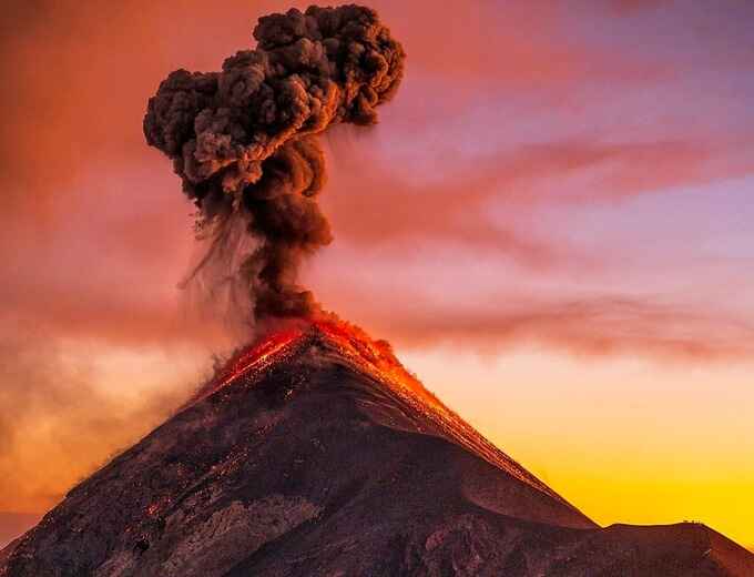
The main attraction of Acatenango Volcano is the view of Fuego Volcano, which at night offers a wonderful show with the different eruptions it produces every 15 or 20 minutes.
In addition, there are views of Antigua Guatemala, Guatemala City, several volcanoes, and Lake Atitlán.
How much time is needed to visit Acatenango Volcano?
The time needed to visit Acatenango Volcano depends on what you want to experience. You can do a one-day visit, although it is not highly recommended due to the physical effort required if you are not experienced, or you can camp to watch the sunrise, meaning you will spend two days on the volcano.
Can you camp on Acatenango Volcano?
Yes, you can camp on Acatenango Volcano. There are specific areas where you can set up your tent. You should have good-quality camping equipment; it must be waterproof and protect you from the low temperatures at the summit.
What are the recommendations for traveling to Acatenango Volcano?
The recommendations for traveling to and climbing Acatenango Volcano are:
What are the biosafety protocols at Acatenango Volcano?
The biosafety protocols for climbing Acatenango Volcano are:
Are pets allowed on Acatenango Volcano?
Yes, pets are allowed on Acatenango Volcano. Dogs are permitted, but you should consider your pet’s physical endurance to know whether it can climb the volcano without complications.
Can you bring food or drinks into Acatenango Volcano?
Yes, you can bring food or drinks into Acatenango Volcano. It is very important to bring food for the ascent, but the consumption of alcoholic beverages is prohibited during the hike.
Are there grills on Acatenango Volcano?
There are no grills during the ascent to Acatenango Volcano.
Is there food for sale or are there restaurants on Acatenango Volcano?
There is no food for sale or restaurants on Acatenango Volcano. Some products are only sold at the official entrance to the volcano and in the towns before the ascent.
Is there parking at Acatenango Volcano?
Acatenango Volcano does not have parking. However, there are private parking lots in La Soledad Village.
Can you take photographs on Acatenango Volcano?
Yes, you can take photographs on Acatenango Volcano. It is one of the favorite places for photography lovers because of the majestic views it offers of part of Guatemala’s volcanic chain and some nearby towns.
Is it necessary to book in advance to go to Acatenango Volcano?
It is not necessary to book in advance to climb Acatenango Volcano; however, you do need to hire a guide service before your visit.
Do you need a guide to go to Acatenango Volcano, and how can you book one?
It is mandatory to use a guide service. To book one, you can contact us and reserve your guide at the phone number +502 57700068.
Is there wheelchair access or access for people with disabilities on Acatenango Volcano?
Acatenango Volcano does not have wheelchair access or access for people with disabilities, due to the instability of some parts of the volcano, as well as its uneven terrain and elevation.
Is Acatenango Volcano suitable or allowed for young children?
Due to the difficulty of the ascent, Acatenango Volcano may or may not be suitable for young children. The physical endurance of the children should be taken into account.
Are bicycles, tricycles, and baby ATVs allowed on Acatenango Volcano?
Bicycles, tricycles, and baby ATVs are not allowed on Acatenango Volcano.
Is Acatenango Volcano suitable for older adults?
Due to the difficulty of the ascent, Acatenango Volcano is not suitable for older adults.
Is there internet, phone signal, or electricity on Acatenango Volcano?
There is no stable internet or phone signal on Acatenango Volcano, and there is also no electricity service because it is a natural area.
Are there restrooms, showers, and changing rooms on Acatenango Volcano?
There are no restrooms, showers, or changing rooms on Acatenango Volcano. There is only a latrine at base camp.
Is there internal transportation on Acatenango Volcano?
Acatenango Volcano does not have internal transportation. However, sometimes you can hire a person to help carry your belongings up, or you can hire a horse, although its use is limited due to animal protection.
What payment methods are used on Acatenango Volcano?
The only payment method on Acatenango Volcano is cash.
Are there ATMs on Acatenango Volcano?
There are no ATMs on Acatenango Volcano, so you must carry cash to pay your entrance fee.
Are there banks to exchange dollars on Acatenango Volcano?
There are no banks to exchange dollars near Acatenango Volcano.
Is there security inside Acatenango Volcano?
There is no security inside Acatenango Volcano; it is a crime-free place.
Are there lockers to store belongings on Acatenango Volcano?
There are no lockers to store belongings on Acatenango Volcano. You must carry your belongings with you at all times.
Are there discounts for large groups or tour operators?
Yes, there are discounts for large groups or tour operators. Prices vary depending on the experience you want to have. You can contact us at +502 57700068.
What events can be held on Acatenango Volcano?
On Acatenango Volcano, no type of events can be held because it is a protected area.
Can birthdays or quinceañeras be organized on Acatenango Volcano?
On Acatenango Volcano, birthdays or quinceañera celebrations cannot be held.
Can First Communions, baptisms, or weddings be held on Acatenango Volcano?
On Acatenango Volcano, First Communions, baptisms, or weddings cannot be held because it is a protected area.
Is there staff available to assist in different languages on Acatenango Volcano?
Yes, there is staff available to assist in different languages on Acatenango Volcano. We have trained guides who can assist in Spanish and English. Book your guide with us at +502 57700068.
What requirements are needed to enter Acatenango Volcano?
The requirements to enter Acatenango Volcano are to pay the entrance fee at the booth and fill out a form for statistical purposes.
Can you do horseback rides on Acatenango Volcano?
On Acatenango Volcano, horseback rides are available up to the volcano camp. The cost is around Q900 and varies depending on how you need the service.
How tall is Acatenango Volcano?
Acatenango Volcano has an elevation of 3,796 meters above sea level and is classified as a difficult-to-climb stratovolcano.
Does Acatenango Volcano have areas for emergency care or medical staff?
Acatenango Volcano does not have areas for emergency care or medical staff. It is important to carry a first aid kit in your hiking gear.
Does it snow on Acatenango Volcano?
Sometimes, due to low temperatures, snow can be seen at the summit of Acatenango Volcano.
What is the contact information for Acatenango Volcano?
+502 5770-0068
info@volcanacatenango.com.gt
Acatenango Volcano has an elevation of 3,976 meters above sea level, making it the 3rd highest volcano in Guatemala and Central America, after the eternally beloved Tacaná and Tajumulco.
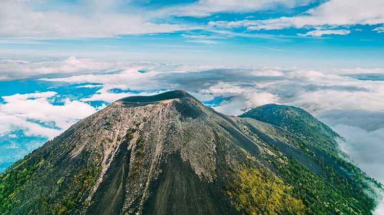
Acatenango Volcano has two summits. The first is called “Yepocapa” or “Tercera María”; it is located to the north and has an elevation of 3,800 meters above sea level. The second summit is the main one and is called “El Plato” or “Bonete”; the “Bonete” summit is located to the south and reaches an elevation of 3,976 meters above sea level.
Don Martín Sis created the first route on Acatenango Volcano, known as “Las 3 Marías”. He began climbing the volcano at the age of 16. This was the first official route, and Don Martín was one of the first guides in the area.
Due to its location, Acatenango Volcano forms part of the Central American Volcanic Arc, which extends for approximately 1,500 kilometers along the Pacific coast of Guatemala, El Salvador, Honduras, Nicaragua, and part of Panama.
According to a legend, the ancient Maya named Acatenango Volcano and Fuego Volcano the “Twin Brothers”, referring to Hunahpú and Ixbalanqué. Hunahpú became the Sun — which is why Fuego Volcano is always active — and Ixbalanqué became the Moon, which is why some of the best moonsets can be seen from the summit of Acatenango Volcano. However, Agua Volcano is known as Hunahpú by nearby communities.
Acatenango Volcano, from approximately 84,000 BCE to the present day, has gone through different evolutionary processes to form the Fuego-Acatenango volcanic complex.
The village of “La Soledad”, which is the main gateway to Acatenango Volcano, was named that way because the daughter of the former landowner was named Soledad.
The union between Acatenango Volcano and Fuego Volcano is known as “La Horqueta”.
Acatenango Volcano is located next to one of the most active volcanoes in Guatemala, Fuego Volcano.
Acatenango Volcano is considered the twin brother of Fuego Volcano because of how close they are to each other.
The last eruption of Acatenango Volcano was in 1972, and it currently has some small fumaroles near the summit.
Acatenango Volcano, together with Fuego Volcano, forms a single massif with three peaks, which is why some mountaineers have named the ascent to this colossus “the triple ascent”.
The trail used to climb Acatenango Volcano has an approximate distance of 14 kilometers round trip.
Climbing Acatenango Volcano is classified as difficult because of its elevation gain; during the ascent, hikers gain around 1,600 meters in altitude.
On very rare occasions during the cold season, Acatenango Volcano’s cone becomes covered with frost or snow. This phenomenon is visible from Guatemala City because of its proximity. In 2010 and 2021, snowfall occurred at the summit.
From the summit of Acatenango Volcano, you can see the summits of the volcanoes Santa María in Quetzaltenango, San Pedro, Tolimán, and Atitlán in Sololá, and if the weather allows it, you can see Tajumulco Volcano, located in the department of San Marcos.
The main attraction of Acatenango Volcano is the view it offers of Fuego Volcano and other volcanoes in Guatemala.
Because of the majesty and views of Acatenango Volcano, some mountaineers describe it as “the most beautiful in America”.
Acatenango Volcano is among the 20 best places to watch sunrises in the world, according to the list created by the UK website Morning.
Acatenango Volcano is one of the 13 most visited volcanoes in Guatemala; this list also includes Fuego Volcano, Agua Volcano, Atitlán Volcano, Ipala Volcano, etc.
On Acatenango Volcano, there are two “hollow trees”. These mark the beginning of the route; the first marks the beginning of the cloud forest, and the second is located at the park entrance.
Acatenango comes from Nahuatl: “tenam,” which means “wall,” “co,” which means “ending,” and “acalt,” which means “corn reed.” Its Spanish composition translates as “Walled Place” or “Wall of Reeds.” This name also belongs to a municipality in Chimaltenango.
Astillero Municipal Volcán de Acatenango Municipal Regional Park, The Enchanted Volcano, Fuego-Acatenango Volcanic Complex, El Consentido
Acatenango Volcano is classified as a stratovolcano and is the third-highest summit in Guatemala’s volcanic chain. It is located between the departments of Chimaltenango and Sacatepéquez, and in the municipalities of San Miguel Dueñas and Acatenango. This colossus has two summits; the first is located to the north and is known as “Yepocapa summit”, while the main summit is known as “El Plato”. It has an elevation of 3,976 meters above sea level.
It is considered a “difficult summit” because it takes approximately 8 hours to reach the top, especially if the trip includes camping. On a one-day trip, it may take approximately 4 to 5 hours to climb to the summit, plus 2 or 3 hours to descend at a fast pace if you are in good physical condition.
From the summit of Acatenango Volcano, on clear days, you can see Guatemala’s volcanic chain, including the summits of Atitlán, Tolimán, Paquisis, San Pedro, Santa María, Santo Tomás, Zunil, and Tajumulco volcanoes, located to the east.
To the south, you can see its twin, Fuego Volcano, the Pacific Ocean, Palín, Escuintla, and Puerto San José. To the east, you can see the colonial city of Antigua Guatemala, San Lucas Sacatepéquez, and Guatemala City, as well as Agua Volcano (Hunahpú), Pacaya, Tecuamburro, and, if the weather allows it, Chingo Volcano on the border with El Salvador.
Acatenango Volcano is connected to Fuego Volcano, and this connection is known as “La Horqueta”. These two volcanoes form the Fuego-Acatenango volcanic massif, which is part of a mountain chain of approximately 5 volcanoes positioned from north to south, perpendicular to the Central American volcanic arc.
The volcanic complex is formed by Ancient Acatenango, Yepocapa summit, the current Pico Mayor of Acatenango, La Meseta, and Fuego Volcano. Spanish settlers called this formation “the Fuego volcanoes”.
This colossus is characterized by not having a crater at its summit. It has a slightly sloped depression with sandy soil, where some people sometimes camp, but the weather conditions are very extreme at that point of the volcano.
Since the creation of the National Council of Protected Areas (CONAP), the area of the “Astillero Municipal Volcán de Acatenango Municipal Regional Park” has been under conservation. The area covers 890.55 hectares and borders the San Sebastián farm located in San Miguel Dueñas, as well as the municipalities of Alotenango, San Pedro Yepocapa, and San Andrés Itzapa.
The main goal of climbing Acatenango Volcano is to watch the majestic eruptions of its twin, Fuego Volcano, one of the most active volcanoes in Guatemala. At night, it offers hikers a show with small eruptions lasting from 5 to 20 seconds, with intervals of 10 to 20 minutes between them.
Through “La Horqueta,” you can reach a ridge located 500 meters from the main crater of Fuego Volcano and watch the eruptions from a closer viewpoint. Another goal for those who climb Acatenango Volcano is to enjoy a sunrise at the main crater, better known as “El Plato.” The ascent from base camp to the crater begins at around 4:30 AM in order to watch the horizon as the sun begins to rise.
Climbing Acatenango Volcano is often a major challenge for many tourists, while for others it serves as training for climbing higher mountains. However, climbing this volcano is a true adventure, and every ascent is a new opportunity to create unique memories.
Some tourists consider this first part of the experience to be the highlight of the adventure, starting at an elevation of 2,500 meters above sea level. It is highly recommended to wear hiking boots. Some hikers have used sports sneakers and ended up with blisters on their feet, have fallen, and their shoes fill with sand, making the trail to the volcano summit unpleasant.
To begin, you should start in the morning. Schedules vary depending on the tour and each person’s physical condition; however, for many, the adventure does not begin exactly when the ascent starts.
Those who will climb the volcano know that a good breakfast is important to start the day with the best energy. That is why some people have breakfast eagerly at their hostels or meeting points before starting the journey from Antigua Guatemala toward the slopes of Acatenango Volcano.
Upon arriving at “La Soledad” Village, where the trail begins, after getting out of the vehicle, there is a chance to buy the last supplies and use the restroom. Then the guides usually give recommendations and some information about the trail before starting the hike.
Different tourists have described the first 2 hours of the trail as “the most difficult”, because the path consists of dirt, gravel, and some improvised steps. Of course, the steepness of that section makes the ascent difficult, but not impossible. However, not all hikers consider only two hours to be difficult. Trekking poles are very helpful for the trail.
At the beginning of the trail, you pass through some corn and bean fields, with no trees to provide shade. Shortly after, the ecosystem changes and the weather becomes cooler. Along the way, you experience 4 different climate zones; it may rain, become completely cloudy and feel like you are walking above the clouds, or the sun may shine very strongly as if you were in a desert. Approximately every 500 meters, the guides will make stops to take a short break and hydrate.
The lunch break is the most anticipated moment, because the rest time is 30 minutes. It is the perfect time to put your backpack aside, stretch, and rest before continuing.
Visitors say that the views along the route make the hike “worth it”, and during breaks they take the opportunity to capture some photos of the views toward several volcanoes and, in the distance, Lake Atitlán.
After approximately 5 or 6 hours of ascent, the camping moment is the most anticipated at the top. Some people climb to the crater to watch the sunset, some have to set up their tents, and others no longer have to worry about that. At that moment, if the weather allows it, you can enjoy a view of Fuego Volcano and some parts of the country. It is the moment hikers look forward to for taking photos before sunset, since base camp is “above the clouds”.
Because of the altitude and after the sun goes down, temperatures drop to -5° Celsius, so it is recommended to bring plenty of warm clothing to keep yourself warm. The guides usually make a campfire near the tents, and that is where they prepare dinner.
Meanwhile, Fuego Volcano, at around 8:00 PM, begins its show of small lava eruptions. Hikers gathered around the campfire can watch this spectacle, with a new explosion occurring every 10 or 20 minutes. This show can only be seen if the weather allows it; otherwise, you will only see a lot of fog and hear the volcano roar and the ground shake.
Some tours offer one more hike before going to sleep, which consists of visiting Fuego Volcano. You walk through La Horqueta and reach a place located about 500 meters from the crater of Fuego Volcano, allowing for a better view of the eruptions.
The route to Fuego Volcano takes approximately 4 hours round trip from base camp. Tourists also consider it a difficult route due to the fatigue from the ascent and the complexity of the trail, which is made of volcanic sand with steep uphill and downhill sections. This route is optional and depends on the experiences hikers want to have.
The only limitations for doing the route to Fuego Volcano may be weather-related, due to the thick fog that often appears at the summit; another may be the volcanic activity of Fuego Volcano; and the last one is the physical fatigue of the participants. In addition, the guide or guides accompanying the group will indicate whether it is a good time to visit Acatenango Volcano’s twin.
The camping and campfire moment is something that some hikers remember very fondly, as it is a time to laugh, eat, and get to know the other people in the group. Sometimes they even join other tourist groups to enjoy better social interaction.
The time to sleep is usually somewhat complicated because of the intense cold at night. Some tourists say that even with “several layers” of cold-weather clothing, the freezing weather that numbs the hands can still be strongly felt. It is important to take this into consideration, and no matter how much warm clothing you bring, it is better not to expose yourself to the low temperatures at the summit of the volcano.
After a nighttime show starring Fuego Volcano, Acatenango Volcano’s twin, very early at 4:00 AM some tourists begin the ascent to the summit, which takes approximately 1 hour and 15 minutes from base camp. The climb becomes difficult because the terrain is volcanic sand, making the trail unstable, in addition to the cold at high altitude and the lack of visibility during the ascent.
Some people decide to climb, others stop halfway to the summit and decide to return, and others, due to the fatigue from the previous day’s ascent, prefer to watch the sunrise from base camp.
Hikers describe this part as “the super difficult part of the ascent”, due to the darkness, poor grip because of the sandy soil, and the altitude that causes some symptoms of “altitude sickness”. However, the view toward the horizon is “spectacular and monumental”; there is a 360° view of the region, completed by the sunrise behind Agua Volcano. The sky can be seen with orange, purple, and blue tones that decorate the landscape, along with the last intense red eruptions of Fuego Volcano.
The dreamlike view from the summit lasts around 30 minutes, during which you can take photos of the sunrise, selfies, and group photos to remember such a majestic moment. You forget the cold when you watch the sun rise!
The return to base camp takes approximately 45 minutes. It is a little easier because the same sand helps you slide down, but you need good balance to avoid falling.
Watching the sunrise ends with a delicious breakfast at camp and a cup of coffee to warm the body and soul.
On some occasions, the weather does not allow you to fully enjoy the sunrise because of cloud cover at the summit.
After breakfast, the return home begins. Those who set up their tents take them down and start packing all their belongings.
The final stretch of the adventure is called by some tourists a “leg burner”, because the way down is more complicated and requires greater effort to support body weight and the fatigue from the previous day.
Although the descent has its own level of difficulty, it takes less time than the ascent, approximately 3 hours with some stops to rest. During the route, temperatures increase, and it is recommended to gradually remove the warm clothing worn from the summit in order to slowly acclimate.
The descent route is the same route used for the ascent; the views vary depending on the weather conditions on the volcano.
Some people are not expert mountaineers, and they encourage others to climb using the phrase “If I could do it, you can too!”.
Most ascents of Acatenango Volcano are usually done in broad daylight; however, for those extreme adventurers, it is possible to climb the volcano at night.
Something to keep in mind for the night ascent is that warm clothing is the most important thing, since you will go through different temperatures along the way. In addition to the necessary gear for the climb, the most important items for this night route are flashlights, trekking poles, and hiking boots. With these essential items, you can have a better hike during the darkness of the night.
These hikes start at around 11:00 PM. This is an option for people who do not want to camp on the volcano, since arrival at base camp would be at approximately 4:00 AM.
The disadvantage of this type of ascent is the timing, as it puts pressure on the route toward the summit in order to fully enjoy the sunrise. Also, once at the summit, you may stay for around 30 or 40 minutes, where you will have breakfast and then begin the descent to return to the trailhead at around 11:00 AM. Another disadvantage is that you will not see Fuego Volcano erupt. So, if you are not experienced in climbing at high altitudes, this type of ascent is not the best idea.