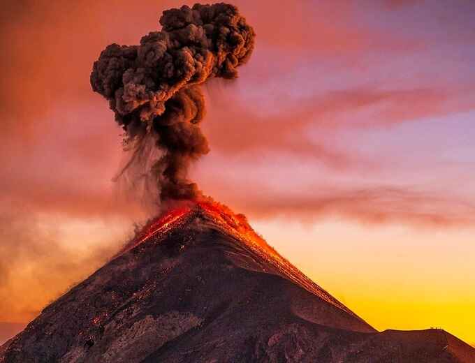
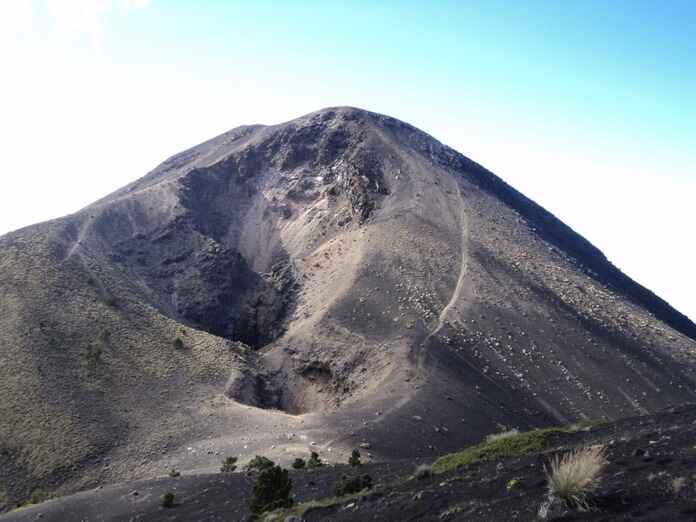
The Acatenango Volcano is located between the departments of Chimaltenango and Sacatepéquez, Guatemala. Approximately 16 kilometers (as the crow flies) southwest of the city of Antigua Guatemala.
To get to the Acatenango Volcano from Guatemala City, you must drive along the Inter-American route CA-1 in the direction of the department of Chimaltenango.
Before leaving Guatemala City, you must drive along the Anillo Periférico and then join the Calzada Roosevelt in the direction of Mixco, continue along the route on the CA-1 to reach the department of Sacatepéquez.
Being in Sacatepéquez, you must pass places like San Lucas, San Bartolomé Milpas Altas, Sumpango and El Tejar, when you reach the Libramiento de Chimaltenango you must turn left joining the CA-1 Occidental / Libramiento de Chimaltenango, the route leads to the Puente de Itzapa, before crossing the the bridge, you must turn right and at the returnnext you must turn left on the Road to Parramos.
You continue the route to Parramos and then the route will change its name to CHM-11 or Parramos-Yepocapa Route, you must continue the path without deviating until you reach the Soledad Village, this community is after the San José Calderas village and is where the start of the ascent to the Acatenango Volcano is.
To get to Acatenango Volcano from Antigua Guatemala, which is the starting point for the different tours to the volcano, you must drive along 3rd Avenue North toward Pastores.
In Pastores, you will drive along RN-14 toward Parramos, then turn toward the municipality of Acatenango. The route you will take is the Parramos-Yepocapa Route, or CHM-11.
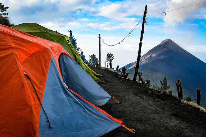
When you arrive in San José Calderas, you will be on RN-10, and in a few kilometers you will reach La Soledad Village, where you can begin the ascent to Acatenango Volcano. The estimated travel time to the trailhead from Antigua Guatemala is 1 hour and 30 minutes.
To get from the department of Chimaltenango to Acatenango Volcano, you must take route RN-14, which then becomes route CHM-11 toward La Soledad Village, where you will begin the ascent to Acatenango Volcano.
To get to Acatenango Volcano from the municipality of San Miguel Dueñas, you can drive along National Route 10 toward the municipality of Acatenango, Chimaltenango, where you can begin the ascent.
Also from San Miguel Dueñas, you can drive along 5th Avenue to connect with National Route 14 toward the municipality of Alotenango. From this location, it is also possible to climb the volcano; however, it is not the official or most tourist-friendly route.
Starting from the municipality of Acatenango, you must drive along route RD-CHM5, then connect with the Parramos-Yepocapa Route, and you should identify the road in La Soledad Village.
To get to Acatenango Volcano from La Soledad Village, it is important to identify the ascent trail among the different crop fields, as this village marks the beginning of the route to the volcano. Public transportation usually stops in front of the trailhead.
To get to Acatenango Volcano from Sipacate, you must drive along Departmental Route 2 toward Santa Lucía Cotzumalguapa.
Along the route, you will pass through places such as La Gomera, Ceiba Amelia, and La Democracia. When you reach Finca San José Miramar, you will find an intersection; you must turn right, and at the roundabout you should turn and return onto CA-2 to head toward Santa Lucía Cotzumalguapa. Then drive along route ESC-11 until you reach the municipality of San Pedro Yepocapa in Chimaltenango. Continue along the route (RD-10), passing through places such as La Cruz, Quisache, and El Tesoro, until you reach La Soledad Village, where you can begin the ascent to the volcano.
To get to Acatenango Volcano from Río Dulce, you must drive along CA-13 toward Guatemala City.
At the beginning of the route, you will need to cross the Río Dulce Bridge, and along the way you will pass through places such as Buenos Aires and La Ensenada. Then you must take the right-hand turnoff onto CA-9 toward Santa Elena.
Continuing along the route, you will pass through the towns of La Ensenada, Mojaca, Santa Elena, Cristina, Los Amates, and La Palmia Village, in the department of Izabal.
You will enter the department of Zacapa through Juan de Paz Village, and you must continue driving along CA-9, passing through places such as Encinitos, Gualán, El Rosario, La Pepesca, Las Pozas, Río Hondo, and Teculután.
When you arrive in San Cristóbal Acasaguastlán, you will be within the jurisdiction of the department of El Progreso, and you must continue along CA-9, also known as the “Jacobo Árbenz Guzmán Highway”. You will pass through places such as Guastatoya, Sanarate, and Agua Caliente.
After Agua Caliente, you will enter the department of Guatemala through the municipality of Palencia, and you must continue along CA-9 toward the department of Chimaltenango, passing the Peripheral Ring Road and then Roosevelt Road to reach Mixco.
Once in Mixco, drive along CA-1 westward, passing through San Lucas Sacatepéquez, San Bartolomé Milpas Altas, Sumpango, and El Tejar. Farther ahead, you will find the Chimaltenango Bypass; you must turn left and continue along the route until you reach Itzapa Bridge.
Before crossing the bridge, you must turn right, and at the next roundabout, turn left and merge onto the road that leads to Parramos. Continue along the route toward the municipality of Acatenango; the route you will take is the Parramos-Yepocapa Route, or CHM-11.
The same route leads you toward San José Calderas. The next town will be La Soledad, where you can begin the ascent to Acatenango Volcano.
To get to Acatenango Volcano from Lanquín, you must drive along routes CA-14 and CA-9 toward Guatemala City.
From Lanquín, drive along RD-AV-06 toward El Pajal, then drive along RN-5 toward San Pedro Carchá, passing through places such as Chiacam and Caquitón.
Once in San Pedro Carchá, head toward Cobán Central Park along RN-5 and 1st Street. When you reach the roundabout, do not take any turnoff and continue along CA-14 toward Santa Cruz Verapaz and then toward Tactic.
In Tactic, continue along CA-14 toward Tulumaje, in El Progreso. Along the route, you will pass through places such as Mocohán, Purulhá, La Unión Barrios, Santa Bárbara, Cumbre de Santa Elena, and Las Limas, in the department of Baja Verapaz.
When you are in the department of El Progreso, you will pass through places such as Vista Hermosa, Cerro Gordo, Santa Gertrudis, Las Pitas, and Tulumajillo until you reach Tulumaje. Then continue along the route until you reach El Rancho. Do not take any turnoff, and drive along CA-9 toward the department of Guatemala, passing through places such as Guastatoya, Sanarate, and Agua Caliente.
After Agua Caliente, you will enter the department of Guatemala through the municipality of Palencia, and you must continue along CA-9 toward the department of Chimaltenango, passing the Peripheral Ring Road and then Roosevelt Road to reach Mixco.
Once in Mixco, drive along CA-1 westward, passing through San Lucas Sacatepéquez, San Bartolomé Milpas Altas, Sumpango, and El Tejar. Farther ahead, you will find the Chimaltenango Bypass, where you must turn left and continue along the route until you reach Itzapa Bridge.
Before crossing the bridge, you must turn right, and at the next roundabout, turn left and merge onto the road that leads to Parramos. Continue along the route toward the municipality of Acatenango; the route you will take is the Parramos-Yepocapa Route, or CHM-11.
The same route leads you toward San José Calderas. The next town will be La Soledad Village, where you can begin the ascent to Acatenango Volcano.
To get to Acatenango Volcano from Flores City, Petén, you must drive along CA-13 toward the department of Guatemala, and then toward the department of Chimaltenango.
Once in downtown Flores, you should head toward Mundo Maya International Airport. Continue until you reach an intersection, where you must turn slightly to the right toward Santa Ana, Petén.
Continue along the route toward Izabal, passing through places such as Santa Ana Vieja, El Chal, Colpetén, Sabaneta, Dolores, Boca del Monte, Machaquilá, Las Delicias, Poptún, Ixobel, San Luis, La Unión, Ixbobo, Canansis, Chacte, La Cumbre, Secoyob, Quebrada Seca, San Pedro Cadenas, and Modesto Méndez.
You must cross the Río Dulce Bridge, and along the way you will pass through places such as Buenos Aires and La Ensenada. Then you must take the right-hand turnoff onto CA-9 toward Santa Elena.
Continuing along the route, you will pass through the towns of La Ensenada, Mojaca, Santa Elena, Cristina, Los Amates, and La Palmia Village, in the department of Izabal.
You will enter the department of Zacapa through Juan de Paz Village, and you must continue driving along CA-9, passing through places such as Encinitos, Gualán, El Rosario, La Pepesca, Las Pozas, Río Hondo, and Teculután.
When you arrive in San Cristóbal Acasaguastlán, you will be within the jurisdiction of the department of El Progreso, and you must continue along CA-9, also known as the “Jacobo Árbenz Guzmán Highway”. You will pass through places such as Guastatoya, Sanarate, and Agua Caliente.
After Agua Caliente, you will enter the department of Guatemala through the municipality of Palencia, and you must continue along CA-9 toward the department of Chimaltenango, passing the Peripheral Ring Road and then Roosevelt Road to reach Mixco.
Once in Mixco, drive along CA-1 westward, passing through San Lucas Sacatepéquez, San Bartolomé Milpas Altas, Sumpango, and El Tejar. Farther ahead, you will find the Chimaltenango Bypass; you must turn left and continue along the route until you reach Itzapa Bridge.
Before crossing the bridge, you must turn right, and at the next roundabout, turn left and merge onto the road that leads to Parramos. Continue along the route toward the municipality of Acatenango; the route you will take is the Parramos-Yepocapa Route, or CHM-11.
The same route leads you toward San José Calderas. The next town will be La Soledad, where you can begin the ascent to Acatenango Volcano.
To get to Acatenango Volcano from Chichicastenango, you must drive along RN-15 toward the department of Chimaltenango.
From Chichicastenango, take National Route 15 (RN-15) toward Los Encuentros, in the department of Sololá. Along the route, you will pass the Chichicastenango Viewpoint. When you reach Los Encuentros, merge onto CA-1 heading east and drive toward Chajalajya Village.
Once in Chajalajya Village, you should drive toward Patzicía, passing through places such as Santa Apolonia, Tecpán, and San José Chirijuyú.
In Patzicía, you must drive along RD-CHM-05 toward the municipality of Acatenango, then continue on the same route toward La Soledad Village, where you can begin the ascent to Acatenango Volcano.
To get to Acatenango Volcano from the town of Panajachel, you must drive along the route toward San Andrés Semetabaj, passing through Patanatic and Xecotoj. Then take the turnoff onto RD-SOL-15 toward Las Cruces.
When you reach the next intersection, you must turn left to merge onto RN-11 and head toward the department of Chimaltenango, passing through Las Canoas and Godínez.
When you arrive at Sabalpop Village, continue along the route toward Patzicía. Along the route, you will find Mocolicxot Bajo Hamlet, Patzún, and Río Blanco La Vega. In Patzicía, head toward San Antonio Nejapa and then toward the municipality of Acatenango.
From Acatenango, along RD-CHM-05, you must drive toward La Soledad Village, where you can begin the ascent to the summit of Acatenango Volcano.
To get to Acatenango Volcano from Xela, you must drive from downtown Quetzaltenango along 29th Avenue until you reach the Tecún Umán Monument, then turn slightly to the right to merge onto Los Altos Highway.
Along the route, you will pass through places such as Curruchique and Salcajá. Farther ahead, before reaching Cuatro Caminos, you must take the right-hand turnoff and merge onto the Inter-American Route CA-1 toward Nahualá, Sololá.
In Nahualá, you must continue along the same route toward Santa Apolonia, passing through Chaquijya, Los Encuentros, and Chajalajya Village. Continue along the route through Tecpán and San José Chirijuyú until you reach Patzicía.
In Patzicía, you must drive along RD-CHM-05 toward the municipality of Acatenango, then continue on the same route toward La Soledad Village, where you can begin the ascent to Acatenango Volcano.
To get to Acatenango Volcano from Esquipulas, Chiquimula, you must take route CA-10 toward the department of Guatemala.
From downtown Esquipulas, drive along CA-10 toward the municipality of Chiquimula, passing through Casa Quemada, Padre Miguel, Tierra Colorada, Santa Teresa, Quezaltepeque, Santa Elena Village, Vado Hondo, and San Esteban. After reaching Chiquimula, continue along the route until you reach Río Hondo, Zacapa, passing through places such as El Ingeniero, Agua Blanca, Santa Rosalía, Zacapa, and Estanzuela.
From Río Hondo, you must take the left-hand turnoff and merge onto CA-9 toward Guatemala City.
When you arrive in San Cristóbal Acasaguastlán, you will be within the jurisdiction of the department of El Progreso, and you must continue along CA-9, also known as the “Jacobo Árbenz Guzmán Highway”. You will pass through places such as Guastatoya, Sanarate, and Agua Caliente.
After Agua Caliente, you will enter the department of Guatemala through the municipality of Palencia, and you must continue along CA-9 toward the department of Chimaltenango, passing the Peripheral Ring Road and then Roosevelt Road to reach Mixco.
Once in Mixco, drive along CA-1 westward, passing through San Lucas Sacatepéquez, San Bartolomé Milpas Altas, Sumpango, and El Tejar. Farther ahead, you will find the Chimaltenango Bypass; you must turn left and continue along the route until you reach Itzapa Bridge.
Before crossing the bridge, you must turn right, and at the next roundabout, turn left and merge onto the road that leads to Parramos. Continue along the route toward the municipality of Acatenango; the route you will take is the Parramos-Yepocapa Route, or CHM-11.
The same route leads you toward San José Calderas. The next town will be La Soledad, where you can begin the ascent to Acatenango Volcano.